Streetscapes: An Opportunity for Re-Visioning our Cities

By John Rufo + Gillan H. Wang

In the recent NY Times Opinion piece about the benefits of banning individually owned cars in Manhattan, Farhad Manjoo touts the merits of wider sidewalks, more efficient public transit, healthier living, and generally more desirable public spaces that enhance and celebrate the pedestrian experience.  The folks at the Practice for Architecture and Urbanism (PAU) have put together a very compelling visual and written argument for people taking back the streets of New York City. At Form + Place we have been thinking about how the Pandemic is shaping the way we use the spaces surrounding our homes, schools, and places of business. The picnic tables on the town common and pop-up outdoor restaurant seating on sidewalks offer a glimpse of a future streetscape that could be more appealing and socially inclusive.  While we expect that vehicular traffic will ultimately return in most communities, it is worth giving some critical thought to the inherent possibilities of a re-imagined streetscape.

 
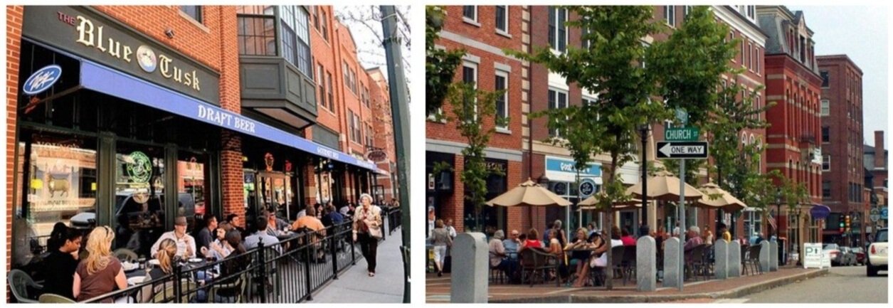
Pedestrian streets creating a place for dining, shopping and strolling

Pedestrian streets creating a place for dining, shopping and strolling


Already familiar with a handful of places (in Boston and beyond) that have closed off former streets to vehicular traffic, we know the joys of strolling and dining in the resulting bustling urban centers.  Pedestrians brushing up against diners, people jostling with bicyclists, and goods brought out from shops to optimize their visibility and appeal, all contribute to a sense of vitality, which in turn draws crowds.  This is an effective method to continue to employ as we re-vision our cities.  In addition, guideline resources such as Complete Streets codify proven successful design interventions such as parklets and curb extensions.

 
Parklets

Parklets


Curb Extensions

Curb Extensions


Some will argue that parking spaces are a valuable commodity and the lifeblood of already precariously poised retail venues in small downtowns and villages. However when it comes to the ends of blocks where restaurants are often sited and where street crossings are most encouraged, the sheer volume of people and activity suggest that visible curb extensions, textural changes to paving, lighting accents and increased signage are all important parts of traffic calming and establishing pedestrian-focused hierarchy.

By applying this model to Newbury Street in Boston, or a suburban town center like Needham, it isn’t hard to imagine a different reality where a larger portion of the street is dedicated to pedestrians, dining and other activities rather than to moving and storing cars. The creative spontaneous response during the COVID crisis where small portions of “streets” are reclaimed for other uses has functioned as a real-time experiment, allowing us to easily imagine our typical street a little differently. Replace the jersey barriers, the traffic cones and temporary galvanized railings with design elements of the same function but better aesthetics, and the street quickly becomes a new kind of enjoyable place to dwell in and share.

 
Photos of Newbury Street and Needham Center

Photos of Newbury Street and Needham Center


Sketches over the above photos showing how easily the streetscape might be improved

Sketches over the above photos showing how easily the streetscape might be improved


Historically, it is only in the course of the last century that the street has come to be dominated by the presence of the privately owned automobile. In ancient and medieval times streets were mostly narrow pathways between buildings, places to route water, goods and sewage, where crosswalks were constructed as literal river crossings.

 
Typical medieval streets and the ancient roads of Pompeii

Typical medieval streets and the ancient roads of Pompeii


The striking juxtaposition of photos of Park Avenue in NYC at the turn of the century and today (as seen in Manjoo’s NY Times article) is a dramatic accounting of good intentions gone awry by changing values.  This is a perfect moment in time to reevaluate our intentions for the built environment of the future.

 
Evolution of Park Avenue

Evolution of Park Avenue


In many European cities, the “sidewalk” and “roadbed” are often barely distinct from one another, beyond a subtle change in paving. This reinforces an understanding that the street is a dynamic entity that can be re-purposed as needs dictate, and this idea is particularly intriguing.  Could the future of our thoughtfully planned streets allow for the capacity to be literally dynamic?  Imagine a boulevard with limited vehicular traffic (perhaps busses and bikes, as PAU describes in their proposal for NYC) which would allow for restaurants and shops to engage the public more directly, and support increased amenities for the passer-by.

Traditionally the boundary between a street and a market is more implicit than explicit.  An open market can take over a street at certain times a day with the barkers calling out to pedestrians.  At night shops shutter their doors and restaurants take the stage, extending their indoor atmosphere and alure to the world of the street.

 
Examples of streets with dynamic edges

Examples of streets with dynamic edges


At a moment when our commuting patterns have been adjusted, our emphasis on public gathering has been refocused, and we are poised to embrace equity in transportation, it’s important to see the temporary adjustments we’ve made to our streets as a first step toward a better design for our towns and cities. Yes, there will still be cars and stop lights and parking meters, but if a larger portion of the street is dedicated to pedestrians and activities of a more human scale, we can humanize our built environment a little more fully, reclaiming some of the real estate lost to our cars and creating a more equitable ownership of the public realm.


Additional sources of inspiration for this post and things we are enjoying reading include:


The Power of Public Spaces

By Michael A. Wang

Photo 1.jpg

The importance of urban public spaces has never seemed greater than during our current times, as we see people seeking out venues, not just for health and recreation but, to have their collective voice heard. According to Charlie McCabe with the Trust for Public Land, public funding for city parks hit $8B nationwide in 2019. While public investment in parks has shown a steady growth in recent decades, history reveals that periods of economic challenge, such as the Great Recession of 2008, can often divert funding from this critical piece of urban infrastructure. The National Recreation and Park Association [NPRA] notes that city spending on public parks plummeted in 2008 by 22%. Despite our current challenges, now is certainly not the time for disinvestment.

 
Bryant Park, NYC

Bryant Park, NYC


The Trust for Public Land states that there should be “a great park within a 10-minute walk of every home, in every neighborhood, in every city across America.” Parks are a platform for equity and as cities begin to formulate urban design goals to address the new realities of the COVID – and, hopefully, post-COVID - world, it is essential that open space remains a priority. This will involve creative approaches to the financing and designing of new parks, as well as new theories for maintaining and repositioning existing assets. Key to the preservation of local parks will be the engagement and empowerment of members of the local community. Allowing a significant degree of self-determination can infuse creative placemaking through the integration of local assets and the celebration of unique cultural influences.

 
Outdoor dining enlivening a narrow street & occupying a “bump out” for dining

Outdoor dining enlivening a narrow street & occupying a “bump out” for dining


One could argue that investment in urban streetscapes will play an equally important role in shaping the economic and cultural well-being of our communities. Many cities are already focusing on expanding bicycle networks and creating more generous pedestrian environments, but this will be more critical than ever as outdoor dining and outdoor retailing seemingly become an essential component to the survival of local businesses. In denser urban contexts where tighter street sections may not allow as much flexibility, cities need to get creative and encourage, for example, the use of pedestrian mews and repurposed on-street parking spaces to provide necessary venues for businesses. The periodic, or permanent, closure of certain streets is another strategy worth exploring, as this can instantaneously create vibrant pedestrian-only environments. If utilized creatively, the changing geometries of a city grid can often create opportunities for small, uniquely shaped parklets.

 
Closing streets to vehicles can create lively pedestrian environments

Closing streets to vehicles can create lively pedestrian environments


Form + Place is currently working with the City of Springfield’s Office of Planning and Economic Development to re-envision the Northeast Downtown District, a neighborhood that was impacted by a natural gas explosion in 2012 that caused widespread damage. Despite being strategically located within walking distance of the downtown core, the new MGM casino and a revamped Union Station, the district has struggled to implement redevelopment. While there is burgeoning interest in integrating more market-rate residential density, the City is proactively contemplating steps to make key public realm improvements. UMass Amherst students in the Department of Landscape Architecture and Regional Planning’s master’s program recently completed an analysis of the district that led to a series of proposed interventions. A common theme that surfaced in every proposal was the importance of the public realm as the unifier of people and place. Building on this theme, Form + Place has implemented a multi-pronged approach to explore the feasibility of catalyzing mixed-use residential development on key parcels while, simultaneously, examining improvements to important commercial corridors, rethinking existing public spaces and contemplating the potential future integration of a major public park.

 
Narrowing a street in Springfield, MA to expand the pedestrian environment

Narrowing a street in Springfield, MA to expand the pedestrian environment


UMASS Amherst LA&RP studio project linking Springfield neighborhoods with open space systems

UMASS Amherst LA&RP studio project linking Springfield neighborhoods with open space systems


Whether focusing on the connectivity of urban neighborhoods or providing flexible open spaces for communal use, it is essential that cities avoid disinvestment in the public realm, as this is a critical component of attracting private redevelopment dollars. There is no doubt that current challenges will cause some residents to retreat from the city, but dense and diverse urban communities will remain and continue to grow, as the world’s population shifts towards urban living. As such, evolution in the design of public spaces will be more critical than ever for supporting a desirable quality of life. Incorporating a variety of flexible, usable public spaces will be a key aspect of thoughtful community-building, but it is also worth noting, as Theaster Gates so eloquently posits in 9 Principles of Ethical Redevelopment, “Place is more about the people who inhabit it and the activities that they engage in than the space itself”.

Photo 9.jpg


Post Pandemic Urbanism: Evolving Trends and their Impact on the Built Environment

By John Rufo

Writing for WIRED Magazine, David Wolman recently said, “…the pandemic’s most valuable lesson, should we finally be willing to receive it, is that the very concept of elsewhere is a fiction. It is naive to think of other places as disconnected from our own geography, our own livesWhere matters—absolutely. But it’s also true that we all live right here. Together”. As architects and planners of space and place, we’re beginning to think about what priorities might rise to the surface as we design our cities and towns in a post-pandemic, or more likely, post “curve-flattened” world.

There have been several through-line trends in the past decade that we’ve written about in this blog which have both pointed toward hope for a more equitable world and spoken to an evolving participation in civic life, connectivity and it’s opposite – social isolation. These trends have their own sense of continuity over time while they also evolve and react to the moment at hand. As we reflect on issues related to the pandemic, three themes emerge.

 
IMG_1490 Crop.jpg
 

The Evolution of Density  

Sustainable density as a current trend in urban development is generally hailed as an important model for future growth. One wonders however whether the ongoing specter of a highly contagious virus will be seized upon by density skeptics to push back on the assumption that it’s the right model. But could it also present the opportunity for a middle ground in which to propose another kind of new urbanism? Somewhere between the unsustainable model of the classic American suburb and the high-density development of residential towers could exist a medium density, nodal development, capable of stitching together the scale of surrounding neighborhoods, while sustainably redeveloping underutilized sites and derelict brownfields.

The spate of new medium density, mixed-use developments set to come out of the ground over the next five years in Newton at Riverside, Needham Street and the Washington Street Corridor will ultimately test the public’s comfort level with living, working and shopping in these environments, post-pandemic. These projects each make significant investments in public realm amenities as well as those for residents and workers. It will be interesting to see just how much the community is willing to engage in the public enhancements of these projects and how residents will feel about occupying exterior open spaces, vs. more intimate spaces such as club rooms, roof patios, fitness rooms, communal kitchens, bars etc. One of the great trends in placemaking around these types of projects has been the inclusion of public open space designed for flexible programming. But will continued social distancing at some level lead to a different understanding of “safe public gathering”? Will large communal spaces be eschewed in favor of smaller gathering spots where we can be with people that we know? Or might small spaces feel too crowded in the new normal?

 
Northland Newton Development

Northland Newton Development


The New Volunteerism

Back in October of 2019, which seems like a century ago, we wrote about Robert Grimm’s exploration of the rate of volunteerism as a metric for how connected people feel to their community. In the current predicament of social distancing amidst a deadly pandemic we have all seen and been a part of the voluntary efforts to make masks, donate funds, distribute food, and do countless other small and heroic deeds that help flatten the curve and help our families and neighbors stay safe. Most of these efforts are focused on basic human needs of health, food, shelter and safety. It’s heartwarming and it represents some of the best of what humanity has to offer.

Combo3 - Copy.jpg

Now Imagine this energy of volunteerism being poured into a post pandemic urban society to address the small and large planning issues of how our cities are designed and how it impacts our neighbors and the community at large. When we go back to work and back to school there will be myriad of competing issues to solve and hours to log in just catching up or rebuilding. As architects, we wonder if a higher awareness of the role of volunteerism will become more ingrained in daily life and impact the public discourse around design and the connective tissues it helps to sow in the community.

 
Rendering.jpg
 

Having been largely deprived of the well-established social norms of public life, will people also see more clearly the direct connection between the design of great places and daily social wellbeing? Are they more likely to volunteer time to efforts like Area Vision Plans and Community Design Charettes? One can imagine a more engaged populace with a new sense of empathy and gratitude for the things that their community provides, wanting to help shape the community more actively. It’s possible that our DNA might literally be changed by this and that a desire for sustained human kindness will need a place to be focused. One of those places can and should be on the design of our cities and other places that impact our daily lives.

Geography and Personal Boundaries

In response to David Wolman’s comment “that we all live right here. Together.” we can’t help but feel that the new “raised consciousness of what is going on around you” will serve as a catalyst for design engagement. Some of us embrace globalism as an ultimate good while others look at it more skeptically, seeing sustained cultural regionalism as a celebration of our differences and as recognition of geographic, climate and environmental diversity. While the two are not mutually exclusive, it is important to recognize what this moment has done to our perception of space across all scales of public life.

 
IMG_9303 Crop.jpg
 

While we like to think about design and planning across a continuum of contexts and scales, we also suddenly have a hyper-curiosity about what is going on in our immediate proximity. How many people in my town have this virus? How many people on my street? Is it in my household? This kind of constant awareness of our immediate perceived boundaries will of course impact how people think about, and possibly guard, their personal space. It therefore stands to reason that people might also be more aware, engaged and vocal about local issues, local development and what development proposals put forth as it relates to private and public space.

Photo+Combo.jpg

In Jan Gehl’s seminal book, Cities for People, he wrote that “Wherever people stay for a while, they seek out places along the edges of the space.” Probably he was not thinking of it in the context of a global pandemic. While the more intimate qualities of the edges of urban space will remain inviting, you wonder if people’s comfort with occupying them will. And if they do occupy those spaces, what are the queues and signals that allow them to feel comfortable and safe? Maybe it is in the details. It seems as we shelter in place, we are all gaining a new appreciation for how important the small details are in our immediate surroundings. While it is troubling to imagine a design imperative to push benches farther apart or not provide moveable seating in a great space like Bryant Park in New York City, you might imagine that the focus on ergonomic and aesthetic detailing of such places might take on new importance. In short, what does appreciation for smaller more intimate places begin to look like while necessarily giving us all just a little more space? What will become of great public spaces like the Boston Public Library or Grand Central Station? And what will become of that great interior design trend in cafes, the communal table?

Conclusion

Time needs to pass and a great deal of events need to play out before we can expect answers to these conjectures. The fact is, it’s difficult to estimate in advance what our appetite for change will be after a siezmic event of this magnatude. At Form + Place, our hope is for a more empathic and engaging world that pays attention to the small details and savors the times that we come together in community to debate our past and render our broader future. Designers, developers, institutions and municipalities will play important roles. We will continue to make plans, large and small. Engaged citizens, a little more nervous about their personal space and a little more intent on shaping the world around them, will continue to participate in a public process. Together we will continue to shape the built environment in a way that recognizes a new reality and brings with it the spirit of a newly connected community.

Unique Solutions: A Challenging Site Offers Opportunities for a New Beginning

By John Rufo

The existing commercial development at One Wheeler Road in Burlington MA is a site familiar to many who drive by it on their way to the shopping, dining and business destinations in this rapidly evolving commercial hub. Lots of people think of it as the “Tweeter Building” though Tweeter Etc. hasn’t been a tenant there for quite some time. Sited adjacent to the north bound exit/entrance ramp at I-95 and the Middlesex Turnpike, the iconic blue-green corrugated metal siding clad building is still there, but not for long.

 
Existing building at One Wheeler Road, Burlington, MA

Existing building at One Wheeler Road, Burlington, MA


The new project that will take its place represents a unique approach to site development and building design, and it has cleared all of the local approval hurdles. The longtime owner of the site, Yu 66 Corporation, is redeveloping it to address today’s retail leasing realities, create an updated sense of curb appeal, and provide a contemporary architectural venue for a new roster of tenants. Not only does the parcel have terrific sight lines exiting and entering I-95, the potential views from the Middlesex Turnpike in both directions make it an obvious candidate for redevelopment to highly visible engaging retail activity.

 
View of proposed redevelopment traveling south on Middlesex Turnpike

View of proposed redevelopment traveling south on Middlesex Turnpike


When Form + Place was engaged by the owner to reimagine a building in this location, three design goals were established:

  • The Façade facing the Middlesex Turnpike would need to be scaled in such a way as to overcome its distance from the street.

  • The “bowl-shaped” topography of the site would need to be turned into an advantage for leasing yield.

  • An iconic tower or other element would be employed to give identity to tenants in less visible areas of the site.

What evolved from these goals was a combined site design strategy by Jim White of H.W. Moore Associates and a building design strategy by Form + Place that would work together to take advantage of topography, maximize tenant identity and create a welcoming engaging environment to shop and dine.

 
View of proposed redevelopment traveling north on Middlesex Turnpike

View of proposed redevelopment traveling north on Middlesex Turnpike


The entire site will be regraded to create a two-level project with a lower level façade addressing Wheeler Road at the main vehicular entrance and an upper level façade facing the Middlesex Turnpike. Stores facing the turnpike will sit at a higher grade level than the existing site affords today and there will be parking directly in front of those stores allowing for ease of access and increased activity.

The building itself has been designed to take advantage of the new site layout and overcome the topographic challenges in a variety of ways. Providing front field parking adjacent to the turnpike necessarily pushes the façade away from the street edge even as it brings the grade up out of the bowl. The building façade responds with a glass line that is taller than many retail venues and a roof height that is higher as well. The expanded glass storefronts and raised roof allow for the tenants to emphasize their identity and exploit the new at-grade site lines to feature store merchandise and branding opportunities.

Evolution of the façade facing Middlesex Turnpike

Evolution of the façade facing Middlesex Turnpike

The tower, as one might imagine, was the subject of much discussion with the Burlington Zoning and Planning Boards. Ultimately a design was agreed upon that will provide an appropriately scaled iconic presence to the building while also giving tenant identity to the Wheeler Road tenants from the I-95 ramps and the Middlesex Turnpike.

Evolution of the corner tower at the Middlesex Turnpike and Wheeler Road

Evolution of the corner tower at the Middlesex Turnpike and Wheeler Road

The smaller corner feature at the Middlesex Turnpike and Wheeler Road also evolved through the course of design and entitlements. Traveling north on the turnpike, the building only becomes visible as one gets close to Wheeler Road, clearing the visual obstruction of neighboring projects. The visibility of the corner of the building, straddling the two grade levels, thus becomes a critical moment in the success of the project as the two retail facades merge and establish the project’s new identity and curb appeal.

As the retail industry continually evolves, it renders certain buildings and sites antiquated and out of date both functionally and aesthetically. At One Wheeler Road in Burlington, the particular characteristics of the bowl-shaped site eventually made the existing development obsolete while creating the potential for a new development to move forward. One of the most important tasks of the design team is to identify creative solutions latent in these kinds of conditions and turn them into added value in the development process.

Leveraging Resources to Foster Positive Change through TAPS

Wareham Village Technical Assistance Panel (TAP)

An Interview with Form + Place Principal, Michael A. Wang

Written by Gillan H. Wang

Presentation Diagram, ULI TAP, Wareham Village 2020

Presentation Diagram, ULI TAP, Wareham Village 2020

The term “TAP” may be unfamiliar to people outside of the A/E/C industry.  What is a TAP and how does it work?

Technical Assistance Panels (TAPs) are essentially a day-long problem-solving charette facilitated by the Urban Land Institute (ULI) and often sponsored by MassDevelopment. The TAP process involves engaging a panel of a diverse professionals to evaluate a particular challenge(s) that a town wants to address. The panelists offer informed and unbiased recommendations that can often provide a road map for a community to attract targeted private investment. Panels typically include architects, landscape architects, civil engineers, real estate developers, land use attorneys, as well as representatives from MassDevelopment, who bring expertise in financing and implementation strategies.

To be considered for a TAP, towns submit an application to the ULI Real Estate Advisory Committee, which determines whether the issues in fact merit exploration.  For example, a town may want to address economic development challenges (vacancies) in their village center brought on by large format retail development on its periphery that draws people away from downtown, or a city might want to reconnect its Main Street with a potentially desirable waterfront area that has been cut off by modern infrastructure.  Each case is unique. 

Once a TAP is approved, co-chairs are selected and the Committee works to assemble a diverse group of panelists based on the nature of the problem (e.g. transportation, parking, zoning, blight, environmental issues, lack of density, etc.). Ultimately, a panel of 7-8 people is identified, which collectively provides a rich range of expertise. 

 
Panel of Experts, ULI TAP, East Milton 2019

Panel of Experts, ULI TAP, East Milton 2019


What are the advantages to a town of utilizing the TAP process?

While development can follow many tracks, building community consensus is a key piece of the equation. A proactive town can work diligently to put forward a clear vision for redevelopment by holding community outreach meetings and developing an implementation strategy. Alternatively, a developer may see an opportunity and attempt to build buy-in from community stakeholders. But, both of these approaches can take considerable time and resources, especially if a municipality does not have consensus regarding its priorities.

The TAP process is unique in that it allows communities to solicit neutral professional advice from outside experts, which town leadership can then use to help focus priorities and expedite implementation.  This can be advantageous when towns find themselves “stuck” on a particular issue.  In a recent TAP in Wareham, MA, for example, the town’s Redevelopment Authority had been utilizing considerable resources on the redevelopment of a former mill site that was outside the core village area. While there was a clear vision to provide a community meeting center, the location was not conducive to driving revitalization of the Main Street corridor and waterfront, which the panel determined to be the necessary focus. So while the town had identified the need to proactively pursue the redevelopment of a catalyzing project, they were not putting their time and resources into the most critical effort.

What sparked your interest to participate in the Wareham TAP?

When the issues were introduced at a Real Estate Advisory Committee meeting, the questions about how to revitalize a struggling Main Street corridor spoke to me – and the unique community building issues that Wareham has identified strongly parallel my professional interests, and those of Form + Place. Helping communities to vision how to reinvent themselves through targeted mixed-use development and placemaking involves understanding their challenges and figuring out how to leverage their assets – it’s a big puzzle! In this particular project, zoning was a critical piece of the equation, as it was determined that bringing more residential density into the center would be an underlying driver of redevelopment opportunities. And while density can be an important building block, there also need to be usable public spaces for community events and gathering – another component clearly missing in Wareham’s village center.

Describe the Wareham Village TAP

For the Wareham TAP, I was a co-chair with Jim Heffernen, a land-use attorney and real estate developer.

Wareham has a Main Street corridor lined by 1-3 story shops, some of which are vacant.  On one side of the street there is a reasonably continuous facade, and the other side of street features mostly free-standing structures/businesses (a post office and a bank with a drive-through). On the side of the street with the continuous façade, there is an unattractive back alley and train tracks that separate the Main Street shops from a potentially attractive waterfront area. Essentially, the challenge Wareham faces is how to connect Main Street to its waterfront asset and create a vibrant village experience.

A large part of the recommended solution was to focus on the back alley (“Merchant’s Way”), including making a one-way street with thoughtfully designed and landscaped parking, allowing for the redevelopment of a buffer zone along the back of the main street buildings. Ideas included promoting a pedestrian-friendly environment through outdoor dining, accommodated on terraces and decks overlooking the water. In addition, changes to zoning could promote denser residential development, both on town-owned lots and on the upper levels of existing Main Street buildings. A multi-faceted approach to placemaking was seen to be another critical ingredient to address, including making improvements to streetscapes, providing a significant public space and rethinking pedestrian mews to create attractive connections to a more accessible waterfront.

 
Walking Tour, ULI TAP, East Milton 2019

Walking Tour, ULI TAP, East Milton 2019


How did your panel arrive at this solution?

The typical TAP requires a 12-hour day, and some preliminary base documentation is assembled by the municipality for review by panelists ahead of time. Here is a typical schedule:

  • Meet town leaders over breakfast meeting (1 hour)

  • Tour of the site / town (1 hour)

  • Stakeholder interviews (2 hours)– residents, business owners, property owners, neighborhood associations, etc. (not including town officials or staff)

  • Panel brainstorming session (5-6 hours) distillation of feedback and impressions of assets and challenges; Develop recommendations and implementation strategies; Prepare graphics and power-point presentation

  • Presentation to general public and town leadership; Q&A (2 hours)

  • Final report published (at a later date)

How often do TAPs produce built results?

ULI recently commissioned a survey to determine the effectiveness of the Technical Assistance Panel program. This report, which will be released to the public shortly, shows that many communities have followed recommendations put forward through the TAP process and that implementation strategies identified have helped unlock opportunities and led to considerable economic development successes in municipalities across Massachusetts.

What have you learned from participating in this process?

Each municipality has its own set of unique variables, but there are a surprising set of common themes found across all communities. People are wary about increases in density and, instead of perceiving it as an economic driver, often fall back on fears of adverse impacts to their lifestyle, including on schools, infrastructure and traffic.

Many towns lack a diverse range of housing options, particularly reasonably priced product for young professionals and housing for the over-55 demographic, who want to downsize but remain in their community.

Strong leadership is a key component to implementing positive change in towns. Having a strong planning and community development staff can certainly help as well, especially when it comes to helping to develop a common vision, securing layered funding resources and being proactive in making key sites development-ready. The TAP program is a unique tool available to communities, not only for helping focus priorities, but for identifying implementation strategies.